Las Aventuras de Artur y Meri

Cuando los otros se van de juerga los fines de semana, nosotros nos vamos a la montaña. Aquí quedan documentadas algunas de estas aventuras.

domingo, 11 de diciembre de 2011

Artur & Meri Toons

domingo, 27 de noviembre de 2011

Red Rock Canyon National Conservation Area, Nevada


There are several red rock canyons, the one close to Las Vegas is the 5th most visited destination for rock climbers in the USA. We haven't climbed for about two years, but there are some friends there and we would like to see what they are doing and maybe try the rock again. 
Top Rope style

Level 10.10C

There are so many cars that all the parking spots are full, so we park on one side of the road. From the second parking area (calico II), our friends take us into a narrow canyon were we find more than 10 groups climbing "top-rope" style. Levels are from 10.7 to >10.10D and our friends are opening routes up to 10.10D. The routes are bolted and have solid ancors at the top. The rock here is redish sandstone. 
Artur and I try a 10.7. How good it is to feel the rock again on my hands! I am surprised of myself to be able to reach the top of my route, although I finish completely exhausted. Soon after that is gets too dark to keep climbing. 


We camp in the first-come first-served red rock canyon campground. There are still spot during the night, although it is almost full. There is water, but only pit toilets. The campsites have a big table covered by a sunroof, which may be great in summer. The night is very cold, below 0C, but there is no wind. The moon is appearing now as a thin crescent over the horizon.
Turtlehead Peak trail
The next morning, we hike up Turtlehead Peak, the highest of the park. We park at Sandstone Quarry parking lot. The hike is just 4 miles one way. It is flat the first half, and steep up the second half. The trail keeps dividing itself so that the mountain is full of trails with no clear direction. Lucklily, the Turtlehead peak is clear and we just hike in its general direction. One can't get lost there. 
In 1hour 20 min we reach the summit. It is after nine in the morning and we are alone when we get there. For 45 minutes we are enjoying the incredible view of Las Vegas and its casinos and the red rock mountains that surround us.


We arrive back at the car at noon, and it takes us a 14 hours drive to get home. Was it worth it? Yes, of course.

Etiquetas: , , , ,

viernes, 25 de noviembre de 2011

Telescope (11,049 ft; 3,367 m) & Wildrose (9,064ft; 2762m) Peaks, Death Valley 
(Cordada Rapel) 


Trail head
It is Thanksgiving weekend and we expect all the roads to be full of traffic, so we leave home at 4am in the morning, expecting to arrive at Death Valley around noon. Luckily we have been early enough to avoid the traffic jams, so we arrive at Thorndike Campground at 12:30pm. There is snow starting from the Charcoal Kilns, but we try to get as far as we can by car. The car gets stuck on the icy road a few hundred meters past the Thorndike campground. The road is steep and we are not far from the Mahogany Flat campground, so we turn around and park in a flat spot between the 2 campgrounds. We take our overnight gear and start walking around 1pm. It is cold (~4C), but the weather is stable and sunny. 


Telescope Peak Summit
In less than 2 hours we are at the spot where we planned to camp, approximately in the middle of the way up. It is early and sunny so we decide to leave the backpacks and summit today. We know that it will be dark after 5pm, but the way back is easy and we can do it with our headlamps. The trail is steeper and longer than we expected and the last 300m of elevation is riddled with switch backs, with plenty of snow and some ice. We don't carry crampons, but we are lucky to have taken the poles. I start  having altitude sickness after one hour of having left the backpack. I am getting a terrible headache and feeling dizzy, but the peak seems so close and so achievable! I keep walking, knowing that Artur is probably perfectly alright and needs to summit today. We arrive at the summit after sunset but still with daylight. It is really windy and cold. We put on everything we carry with us and hurry down after the obligatory summit picture. 
In 1hour 30 min we get back to our backpacks. It is completely dark - we have a moonless night. We walk down still 30 minutes more until we find the nice camping spot that we saw coming up. We set up our tent, prepare a hot dinner and finally rest. We are at more than 3000m altitude. We can still feel the altitude and the temperature has dropped to below freezing, actually outside the tent we are at -5C (23F). But then, the surprise, the moment than all mountaineers enjoy, the view that no picture can show: a perfectly moonless sky, with stars so shiny than seem closer to us, like if we could reach them. The wind is not blowing any more, the beauty is breathtaking. 
Telescope peak from the trail going down
Our tent in the morning


The next day, another blue sky and freezing temperatures. Luckily the water and gas were in our sleeping bag so they are not frozen. We have a hot breakfast, pack and hike down to the parking lot in ~2hours. 
The day is so beautiful and it is so early that we decide to hike Wildrose peak , a 8.5 miles round trip from the Charcoal Kilns parking lot.  


That peak is easy, pretty steep and it is extremely windy at the top. 
The trail is also longer than expected, with a long detour to the east before heading to the peak, but it is very easy to follow and we run into plenty of people, including kids. 
Wildrose Peak Summit
The view is quite spectacular, we can see Death Valley quite well. Worth coming up. Now, Las Vegas waits for us!

Etiquetas: , ,

lunes, 17 de octubre de 2011

4 Tarantulas, 4 snakes and a lot of thinking
Joseph D. Grant State Park

My grandmother passed away last Wednesday and we decided to walk in her remembrance. Most of my family were walking at the other side of the world, from Collcerola to Valldoreig, so Artur and I made our little walk in the surroundings of Silicon valley. 
It was a sunny day that certainly would have pleased my grandmother. 
The last few days I have thought so much about her advices about so many things that I dedicate this walk to her words of wisdom.


While Artur and I walked talking about the meaning of life, some snakes and some tarantulas passed in front of us, just in the middle of our trail. I am wondering: why today? Is it a reminder that life is so little? That any day any of us can go?


May nature give us her blessings and let us wander on her trails for as long as possible.

Etiquetas: ,

viernes, 24 de junio de 2011

Crossing Supercreeks at Kings Canyon 
(Cordada Rapel) 
We know for sure that Kings Canyon is the place to go if we want to find a wilderness permit at the last moment. Not being as famous as Yosemite and Sequoia makes this wonderful park crowd-free. Also, the road 180 incorporates a new piece of highway every year, so that the original 5 hours and a half that used to take us to get there have been converted in 4 hours and a half. We leave on Friday at 7pm and arrive there around midnight because of the traffic jam getting out of the Valley, specially near San Jose and after Gilroy in Pacheco Pass. Unfortunately, it is almost impossible avoid these traffic jams unless we leave very early on Saturday. The campgrounds in the Cedar Grove area are almost empty aso we can choose where to camp. Saturday morning the wilderness permit station at Roads End starts offering permits at 7am. There are only 2 people in front of us to get the permit and it's already 9am. That is great! 
We have read everywhere that there is a lot of snow up in the high Sierra and the weather has been terribly good for the last week so there will be plenty of water on the creeks. Just in case, we have taken snowshoes, crampons and snow gear, but as soon as we see the mountains we realize that the snow is way higher than we expected. The weather for this weekend is also expected to be good so we leave most of our winter gear in the car. The backpack, though, is still pretty heavy: we carry the bear canister, tent, winter sleeping bag and more winter clothes than we should carry. 
Our chosen trailhead is Lewis Trail, just before Cedar Grove. The idea is to hike to Frypan Meadow, set camp there, and hike Mt. Harrington the next morning (11009ft, 3355mt.). 
The beginning of the trail in pretty steep. We hike around 5 miles and almost 2000ft of altitude in about 2-3 hours and we stop to rest. I am exhausted and need a long rest to continue. We have passed to creeks that have way to much water, so we hike up the creek until we find a bit tree that we can walk on to cross safe.
 After walking a little while more, though, the Lewis creek crossing becomes an impossible mission. The water is too fast and there is too much. The tree to cross is too thin and is wet and sleepery. We don't feel confortable crossing with our big backpacks. We hike up along the right side of the creek, trying to find a better place to cross, but after one hour of bushwhaking we realize that we are not going to find the crossing spot and we are becoming too tired. So we decide to search for a nice place to pass the night in a saddle at 7800 feet. It takes us one hour more to get there, but there aren't any other spots free of bush and flat where we can set our overnight camp. When we set camp we have run out of water, so we still have to walk to the creek (down 15 minutes more) to get some dirty water and potabilize it. 
The evening is warm and we still have many hours of light, we can practice ioga and climb some boulders around and hear the birds and the animals that suround us. It is really a wonderful summer day. We couldn't have choosen a better weekend. 
The next morning we hike up the ridge until there is too much snow to continue. The snow starts at around 8000 ft and it is still hard enough so that we can walk easily on top without problems. We arrive just over the psicological line of 3000mt (9862ft) and decide to hike down. 
To be our first mountaneering weekend of the summer we are quite happy. 
The sour muscles will last this time 4 days, but it has been worth it. 

Etiquetas: , ,

domingo, 24 de abril de 2011

Water, Wasser, Aigua
San Jordi 2011
Yosemite National Park
(Rudy, Artur i Meri)


Per San Jordi toquen roses, ja ho sé, però aquest cop tot va ser aigua.... per tots costats. 


Posted by Picasa

Etiquetas: ,

lunes, 16 de agosto de 2010

Mt. Gibbs (12764 ft, 3890 m) and Monroe Hall Research Natural Area
(Artur and Meri)


East of Tioga Pass there are several campgrounds that are a lot smaller than Tuolumme Meadows and have a higher chance to have free sites on Saturday morning. We wanted to try Sawmill Campground, a walk-in campground that seemed peaceful because of the fact that you have to walk a while to arrive at the campsite. As we expected, the place was nice, clean and calm and we were lucky to get the last free spot on Saturday noon.

It took us 3 trips to the car, each one 10 minutes, to bring all our stuff to the site. As it was hot and I didn't remember that we would be so far from the car, we had taken the cooler and the big stove. After having lunch, instead of going to the car again, we just started walking from our campsite to the Carnegie Institute Experimental Station. This was a really good choice. There is a well maintained path to the station and it continues into the Monroe Hall Research Natural Area. The trail enters into the valley that leads to Mount Conness (12590 ft) and White Mountain (12057 ft), wandering on the right of Lee Vining Creek. The valley is gorgeous at this time of the year. The snow has almost completely melted and everywhere you look it is full of water and flowers. We found quite a lot of people on the trail, including groups of rock climbers. We are not sure but we think they are climbing the south-east wall of Mt. Conness. Following the trail, it took us around 2 and a half hours to get to the top of the saddle and walk a little bit along the ridge to Mt. Conness. As it was getting late, we didn't have time to reach the peak of Mt. Conness. There may have been at least another hour left to go. In 2 hours we arrived back to our campsite, just as the sun was setting. We still saw 3 or 4 rock climbing teams passing by and were wondering where they were all coming from.
Artur in front of Mt. Conness

On Sunday morning we heard voices at 4am, some rock climbers passing very close our tent, apparently a little lost and off trail. Where were they going? Its still a mystery. We got up at 7am and saw several more teams of people with ropes and helmets going in direction of Mt. Conness.

After breakfast, and only 2 trips to load the car, we left the quiet campground towards Tioga Pass and parked at Mono Pass trail head (it has 3 bear lockers). From there, we hiked 1h30min gently sloping up to Mono Pass.
Mono Pass

Then we started hiking up Mt. Gibbs by the south-southeast ridge. The terrain is full of loose rocks so our pace was rather slow, but in around 2 hours we arrived at the peak. We didn't see any other people on the trail (or lack thereof), but read in the summit register that at least 2 groups of people had climbed the peak earlier the same day. As it was sunny, not very windy, and still early we had lunch and took a nap before starting down.
The amount of flowers in this area was spectacular. The snow was also almost completely melted and the landscape was full of colors of the different flowers.
We hiked down on the north-west ridge. There are some areas with big rocks and steep slopes that slowed us down a little bit, but in general it was easier going then the south ridge on the way up. In 2h 30 minutes we were back at the car without major problems. The streams at this time of year are quite low on water or altogether dried out so we could cross them without difficulty.

Etiquetas: , ,

lunes, 2 de agosto de 2010

Sunnyside Bench Trail (Upper Falls) and Ledge Trail (Glacier Point) - Yosemite Valley
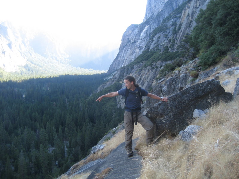
(Cordada Rapel)


Yosemite Valley is usually so crowded that doing a hike without people seems impossible.... unless you go to Sunnyside Bench Trail or the Ledge Trail. Both are half-day hikes, mainly class II with some class III steps. Both are very steep, slippery at moments and exposed. Those trails feature lots of adrenaline for normal hikers and fun for rock climbers.

The Sunnyside Bench trail hikes up to the bottom right hand side of the Upper Falls, just below the base of Lost Arrow Spire. It took us 2 hours to climb up and about half that time to go down. We were surprised by a rattlesnake on our way up and a smaller stripped black/yellow Garter Snake on the way down.
The first half of the trail is quite flat and easy to follow but it is very exposed. You don't want to slip here. Later it becomes steepper and there are some class III steps also with a bit of exposure. The last part is mainly slabs and the main danger is the sand on top of them. The view from the top is beautiful. The Upper Falls are near but not enough to get wet.

We did this as an afternoon hike. The good news is that after the way down there is the store and an ice-cream was waiting for us.
On the next morning we hiked the Ledge Trail. It seems to be the third deadliest trail in Yosemite. Well, if I had known that before, I may not have done it. The reality is that it was beautiful, especially the couloir at the end. It took us 3 hours to arrive at the intersection with the 4-mile trail, almost at Glacier Point. And then, 2 more hours to get down to the road by the 4-mile trail. The Ledge Trail itself is exposed and slippery at some crucial moments. The good news is that it is well marked by yellow and orange stripes, so when we doubted we just had to look for them.

The first 2 thirds of the trail are dry and rocky, but when we turn left into the couloir the trail changes completely.
It becomes like a small garden full of flowers, with a creek in the middle that we had to cross several times. It is so full of vegetation that we had some difficulties to follow the marks and cut through the bushes. Sometimes the vegetation was so thick that we could not even see our feet. Here we also encountered the added difficulty of slippery wet rock.

Both are recommendable hikes to avoid people but they are risky and can have bad surprises. The snakes, though, were good with us.

Etiquetas:

lunes, 19 de julio de 2010

Tenaya Peak (10280 ft / 3133 m) and Mt. Hoffmann (10850 ft / 3307 m) - Yosemite National Park
(Carlos, Rudy, Artur and Meri)


Both are day hikes, not strenuous and incredibly beautiful. It took us 2 hours to get to Tenaya Peak from the Tenaya Lake (Sunrise trailhead).

Rudy in front of Half-Dome and Yosemite Valley

It is a crosscountry hike, with a lot of slabs and some grade III passes that can be avoided depending on the way up. Our only adventure was crossing the river at the begining of the hike. There was too much water so we had to take off our shoes to cross, wading through the calf-high stream. We hiked up a little east of the south ridge, staying west of the stream that runs down the valley, and hiked down via Mildred Lake. In a bit more than one hour we were cooling our toes on the beach of Tenaya Lake.

Tenaya Peak throning above Tenaya Lake


One of the most beautiful views from Tenaya Peak is the Yosemite Valley from the north-east side, with a spectacular view of Half-Dome from the side that sports the trail on which people hike to its top. The mosquitoes attacked us all day long, as the day was hot and they were hungry.

Before the hike we secured a campsite at White Wolf, one of the campgrounds on Tioga Pass Road. Luckily this weekend there were fewer people in the park than last time we were there, so we did not need to spend extra time driving around to various campgrounds to find a place to pitch our tents. Also this time our site was virtually mosquito free, unlike last time.

On Sunday we climbed Mount Hoffmann. This too is a short day hike, even easier than Tenaya Peak. We left the car at May Lake trailhead, which has ample space for parking and has plenty of bear lockers. There is a trail all the way from the lake to the top of the mountain which makes it busier than Tenaya Peak on which we saw only the odd climbing party on their descent.
Mount Hoffmann
While Rudy and Meri were arriving in less that 2 hours to the 'official' top (the one with the antenna), Artur had time to climb that one as well as the 3 minor peaks. Carlos reached us on the first peak just as we were starting to head down.
The mosquitoes were a lot worse than the previous day and we were all but bathing in bug repellent to keep them at bay. After lunch, though, they seemed to rest from the heat and give us a break.
Again, in little over one hour we were back at the car, ready for a good wash in a nearby creek.


Etiquetas: ,

miércoles, 7 de julio de 2010

Tuolumne Meadows Menagerie & Mt.Dana (13053ft - 3979m)
(Nighty Night Deer, Dana Peak Marmot, Lembert Dome Chipmunk, Campground Rabbit, Plenty of Huge Mosquitoes & Cordada Rapel )

On Saturday 4am we woke up for a long weekend. We wanted to arrive at Tuolumne Meadows before anyone else to get a first-come first-served campsite. Of course, it was the busiest weekend of the year in Tuolumne Meadows, and the first one with open campgrounds, so our attempt was futile. Some of the campgrounds were still closed for too much snow or water and the others were already packed from the previous days. We drove to the east of Tioga Pass looking for more campgrounds and still found some full and some closed. We found the first free campsite at the last campground that appeared on our map, Aspen Campground. The mosquitoes ravaged us without mercy. Luckily the weather was good and we could still get some exercise bushwhacking from the campground to a no-name 9500 ft peak in direction of Mount Dana.
Later that evening we had company from a deer, which would insist during 2 nights in keeping us company for a while (and trying to steal our food from the table).


On Sunday morning, we got up at 6 to hike Mt. Dana. The previous day we had seen that we didn't need any snow gear unlike expected. There were only a few patches of snow along the whole route, and even those could easily be avoided if necessary. It took us 3.5 hours from the Mono Pass trail head at Tioga Road to the peak (13053ft, 3979m). From the trailhead, we walked less than one mile until we got to the crossing with Dana Fork river. Then, we continued on the left side of the river and hiked up by the west ridge. On the top, a highwayman marmot was trying to get some of our food. Given its well fed appearance it had obviously been successful with its overt attempts on other mountaneers.
We hiked down via the south-east ridge. Our original idea was to traverse to Mt. Gibbs, but we were too tired for that and it would have made for a very long day. We hiked back to the parking lot following the right side of the Dana Fork river, same as we came up. We needed more than 3 hours to make it back. The rocks of Mount Dana's eastern slope are big and not very stable, so our pace was slower than usual.

The next day we changed to Tuolumne Meadows Campground inside the National Park. From there, we hiked to another no-name peak on the way to Ragged Peak, with an altitude of ~10400 ft. It was a very nice hike, and I highly recommend it. We returned via Lembert Dome (9450ft), hiking the easy peak from the east side and going back to the campground via the Pacific Crest Trail at the side of the Lyell Fork River. We were surprised by the little beaches that we found around this side of the meadows and enjoyed being able to wash our dust covered faces in the clear snowmelt water.

In the evening a seemingly very confused and lost rabbit came to search refuge at our tent for a couple of hours.

Tuesday was the day we had to go back home, but we wanted to do at least some short hike. So we decided to climb Indian Rock peak. The trailhead is one mile before Porcupine Campground and has bear boxes. It is a weird hike because you start going down before you actually climb. It was only a few miles, so in 1h10min we were on the top.
The view is spectacular - from Indian Rock one can see the north-west face of Half Dome.
Not surprisingly, and after wonderful weather for 4 days, we started seeing black clouds growing quickly above us. A thunderstorm formed rapidly and we had just enough time to get to the car before the clouds started to let out their content, accompanied by angry growling. Few minutes later our car was bathed in hail. Pretty scary to be out there with those ice rocks coming down onto your head.

Etiquetas: